
Before Entering Voyageurs National Park:
Visitor centers are located on Rainy Lake, Kabetogama, Ash River and Crane Lake. Permits are required, and reservations can be made. Consult Park officials for current fees and regulations. There are primitive boat-in campsites scattered throughout the Park. U.S. Coast Guard buoys and markers are provided for navigation. Care should be taken when traveling on the water because of the many submerged reefs, rocks, logs and the varying water levels.
Visitor centers are located on Rainy Lake, Kabetogama, Ash River and Crane Lake. Permits are required, and reservations can be made. Consult Park officials for current fees and regulations. There are primitive boat-in campsites scattered throughout the Park. U.S. Coast Guard buoys and markers are provided for navigation. Care should be taken when traveling on the water because of the many submerged reefs, rocks, logs and the varying water levels.
mouse over to zoom
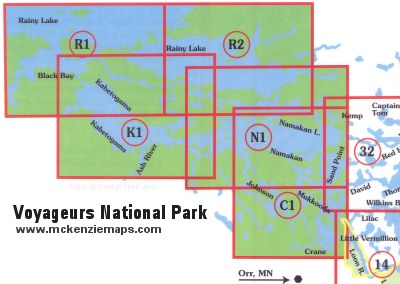
Voyaguers National Park Complete Map Set
This set of maps includes numbers K1, N1, C1, R1 and R2 that cover the entire Voyaguers National Park. Scale is 1:31680.
Map C1 - Crane Lake and Sand Point
This map details the southeastern portion of Voyageurs National Park, including Crane Lake and Sand Point. Scale is 1:31680.
Map K1 - Kabetogama Lake
This map details the southwest portion of Voyageurs National Park, including Kabetogama Lake and Ash River. Scale is 1:31680.
Map N1 - Namakan Lake and Sand Point
This map details the eastern portion of Voyageurs National Park, including Namakan Lake and Sand Point. Scale is 1:31680.
Map R1 - Rainy Lake southwest area
This map details the northwestern portion of Voyageurs National Park. Including the southwest area of Rainy Lake. Scale is 1:31680.
Map R2 - Rainy Lake southeast Area
This map details the northeastern portion of Voyageurs National Park. Including the southeastern area of Rainy Lake. Scale is 1:31680.